

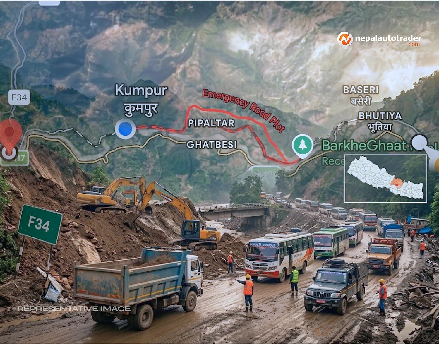
Flooding in the Trishuli River has done more than damage individual stretches of pavement. It has disrupted the links that keep communities, commercial traffic and essential services moving through parts of Dhading, Nuwakot and Rasuwa.
According to information provided by the Ministry of Physical Infrastructure Development, several roads have now been constructed, repaired or upgraded as temporary and alternative connections. The work is being carried out in response to damage affecting the Galchhi-Trishuli Highway and bridges across the Trishuli River.
The response is practical rather than glamorous. Heavy equipment is being deployed, landslides are being cleared and damaged road surfaces are being made usable again. But for people who depend on these routes every day, these are not temporary engineering exercises. They are lifelines.
One of the most important alternatives is the 15 km Prithvi Highway-Dhadingbesi route. It begins at Mastar on Prithvi Highway, crosses the Trishuli bridge and continues through Keurinitar, Belinitar, Adamtar, Pipaltar, Gajuritar, Nepaltar and Parewatar before reaching Dhadingbesi.
The route is intended to serve areas affected in Galchhi and Siddhalek. Its importance is easy to understand. When a major highway connection is compromised, restoring a physical link to a district headquarters can matter just as much as reopening the main highway itself.
This route follows earlier efforts to restore access to Dhadingbesi after flood damage affected a bridge over the Trishuli River. Nepal Auto had previously reported that the Parewatar-Nepaltar-Gajuritar-Pipaltar-Adamtar-Belinitar-Keurinitar-Mastar connection had been brought into operation.
For drivers, the key point is simple. The road network is functioning through a new combination of links rather than relying entirely on the damaged main corridor.
The largest of the newly identified alternatives covers 40 km. It provides a connection to settlements on the far side of the Trishuli River, beginning from the Galchhi-Trishuli Highway and continuing from beyond the Trishuli bridge along the right bank of the river.
The route passes through Kalleritar, Koshikhola, Pimaltar, Darshantar, Chhatrekhola and Gauribesi before reaching Trishuli Bazaar and the boundary of Kispang Rural Municipality.
| Alternate route | Length | Primary affected areas |
|---|---|---|
| Prithvi Highway-Dhadingbesi | 15 km | Dhading's Galchhi and Siddhalek |
| Trishuli crossing area route | 40 km | Dhading's Siddhalek and Nuwakot's Tarkeshwar, Bidur and Meghang |
| Devighat Tadi Khola bridge alternative | 35 km | Nuwakot's Bidur and Belkotgadhi |
| Rasuwa access route | 12 km | Nuwakot's Bidur and Suryagadhi |
That connection matters because road damage does not stop at the point where pavement disappears. A washed-out bridge can isolate an entire network of settlements even when roads on either side remain intact.
At Devighat, the damaged Tadi Khola bridge has created another weak point in the network. Authorities have responded by putting a 35 km alternative route into operation for four-wheel-drive and other four-wheeled vehicles.
The route runs through Pipaltar, Dhamale, Niranjana, Bagkhore, Harre, Deurali and Kolputar. It serves the areas of Bidur and Belkotgadhi in Nuwakot.
For motorists, this is the sort of route that can easily be overlooked on a normal map. During a disruption, however, a secondary road suddenly becomes a critical transport corridor.
The broader lesson is uncomfortable but familiar. Nepal's highways are only as resilient as the bridges, culverts and slopes that support them.
Access toward Rasuwa presents a more complicated challenge because the highway between Trishuli and Betrawati has been damaged. The alternative connection uses Dhikure on the Mid-Hill Highway and continues through Fedi Besichok, Hiramunitar, Chogte, Borebhanjyang, Sano Khola, Dhanswara, Bhorle, Jibjibe and Bogatitar.
The operational section in Nuwakot covers 12 km. Repair work is also continuing on the Rasuwa section.
This route is particularly important for maintaining access rather than simply providing a detour for through traffic. The affected areas include Bidur and Suryagadhi in Nuwakot, while the wider objective is to keep Rasuwa connected as repairs progress.
The situation follows broader flood damage in the region. Earlier reporting indicated that approximately 40 km of road in Rasuwa had been completely damaged by flooding, while around 10 km between Galchhi and Trishuli was closed. The same report said 41 bridges had been completely damaged.
Road Division Nuwakot is continuing emergency work using equipment to clear roads and landslides, construct culverts, improve road surfaces and place gravel where required.
This is where the story moves beyond a simple list of alternate roads. The immediate task is not only opening a route, but keeping it usable as weather, traffic and unstable terrain continue to test the network.
The response also comes as other alternative corridors are absorbing additional traffic. When the Prithvi Highway was disrupted around Krishnabhir, traffic was redirected toward the Kathmandu-Hetauda corridor, increasing pressure on routes through Sisneri and Pharping.
For now, these alternate roads provide a vital buffer. They give communities another way to move people and goods while damaged infrastructure is assessed and repaired.
But alternate roads are not a substitute for resilient primary highways. Their value is greatest when they buy engineers and authorities enough time to restore the main network safely rather than forcing traffic back onto damaged sections too quickly.
The wider recovery effort will therefore depend on two tracks moving together: emergency access through alternatives and permanent reconstruction of the damaged highway and bridge network.
Recent reporting shows that the Prithvi Highway has already been reopened in stages after mud and debris were cleared from the Galchhi-Malekhu section, with essential traffic allowed to move first.
That distinction matters. A road being technically open does not necessarily mean it has returned to normal.
For drivers heading into the affected districts, the safest approach remains straightforward: check current road conditions before leaving, expect changing conditions and follow directions from traffic authorities and local officials.
Nepal's mountain roads rarely offer much margin for error. After a flood, that margin becomes even smaller.
Q: How long is the alternate road between Prithvi Highway and Dhadingbesi?
A: The alternate route is 15 km long. It runs from Mastar on Prithvi Highway through several settlements before reaching Dhadingbesi.
Q: Which alternate route connects areas across the Trishuli River?
A: A 40 km route has been put into operation along the right bank of the Trishuli River, connecting areas from beyond the Trishuli bridge toward Trishuli Bazaar and the Kispang Rural Municipality boundary.
Q: Is there an alternative to the damaged Tadi Khola bridge at Devighat?
A: Yes. A 35 km route through Pipaltar, Dhamale, Niranjana, Bagkhore, Harre, Deurali and Kolputar has been opened for four-wheeled vehicles.
Q: What route can be used for access toward Rasuwa?
A: A 12 km Nuwakot section through Dhikure and a series of connecting settlements has been made operational while repairs continue on the Rasuwa section.
Q: Who is carrying out the emergency road work?
A: Road Division Nuwakot is carrying out emergency work including road opening, landslide removal, culvert construction, surface improvement and gravel placement.
Q: Are these alternate roads a permanent replacement for the damaged highways?
A: No. They are being used to maintain connectivity while damaged roads and bridges are repaired. The longer-term priority remains restoring the primary road network safely and reliably.

Nepal Auto-Trader is one-stop platform for all automotive needs. We provide unbiased and unparalleled news/reviews of all auto-motives being launched in Nepalese Auto-Industry. Find recent updates and price of bikes/cars, compare and review recently launched bikes/cars, buy/sell/trade reconditioned cars/bikes and all government news about changing rules and regulation, road safety by subscribing us.

Subscribe to our Newsletter
© Copyright 2026, Nepal Autotrader



.png)
.png)